Sugar Creek L-44: Dam Danger Averted
As the remainder of Tropical Depression Erin swept across Oklahoma on the weekend of Aug. 18-19, rainfall amounts fell in parts of Caddo County that greatly exceeded that of a 100-year frequency storm. Preliminary results of the rainfall in the drainage area above Sugar Creek Dam L-44 indicate that over eight inches of rain fell in less than 12 hours. Sugar Creek Watershed Dam L- 44 in Caddo County, Okla., is one of 51 flood control dams in the Sugar Creek Watershed Project.
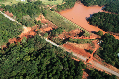
The dam was designed as part of a series of dams that collect water during heavy rainstorms and slowly release it over a period of days to control flooding downstream from dams and from downstream rivers such as the Washita. They are usually designed for 100-year frequency storms. The Sugar Creek 44 L Dam was designed to store and safely pass flood waters from a 6.5 inch rain within a 24 hour period.
Water under most conditions flows out of the structure through a pipe in the dam. When the pipe spillway can not handle all the water flow, it flows through the earthen spillway. This was the case with this dam. Even the earthen spillway could not handle all the water and that caused the erosion in the spillway and to the dam.
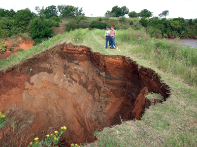
On Sunday Aug. 19 at approximately 10:00 a.m., Caddo County Sheriff Gene Cain contacted Roy Green, South Caddo Conservation District manager, and informed him the dam was at flood stage and was suffering critical erosion on its face. Green asked Cain to begin warning area residents of the potential hazard of a breach and to encourage people to evacuate. That was the beginning of the implementation of the emergency action plan designed for each of the 2,105 upstream flood control structures in the state. The emergency action plan was implemented by the South Caddo Conservation District and USDA Natural Resources Conservation Service (NRCS) to ensure the safety of those downstream in case the dam were to fail, and staff from those two agencies immediately went to the site to monitor conditions. Larry McDuffey, Caddo County Emergency Management director, enacted the county’s emergency action plan and began evacuating residents.
Throughout the week the dam was continually monitored by district staff, NRCS engineers and Oklahoma Conservation Commission watershed technicians. Dale Vineyard, an area contractor, immediately redirected earth moving equipment to dig a ditch in the earthen spillway to help the lake drain faster and reduce pressure on the dam. He also built a road to the dam to allow OCC to bring in two large water pumps to speed draining the lake. With financial assistance from the NRCS Emergency Watershed Protection Program, concrete barriers were hauled in and placed around a residence to protect it should the dam have failed.
“A lot of people pitched in to help avoid a high risk situation,” said Ron Walzer. Walzer sits on the South Caddo Conservation District board of directors and was on site representing the district as well as providing local advice and counsel. “Benny Bowling, our county commissioner, provided equipment, material and road building needed to flood proof the house that could have experienced five feet of flood water if the dam had breached,” Walzer said. “Dale Lasley, the county flood plain manager, provided the forms needed for the Emergency Watershed Protection Program,” he said. “And landowners like David Nault and Stephen Quoetone helped with communications, equipment and easements. And we sure appreciate state Rep. Phil Richardson for making a site visit to assess the situation,” Walzer added.
The dam is located three miles north of Anadarko on Highway 81 and three and a half miles west. The dam discharges into Lost Creek and flows approximately one mile before entering the Washita River four miles west of Anadarko. The dam was constructed in 1971 as a low hazard dam to protect rural agricultural land from flooding. It was reclassified as a high hazard dam in 2005 due to the construction of homes downstream that would be affected if the dam were to breach.
South Caddo Conservation District is working with NRCS planners and engineers to formulate plans for repairs to the dam.